KNOW BEFORE
YOU GO

OFFSHORE FISHING WEATHER INTELLIGENCE
LIVE
GET MY FORECAST →
No password · No credit card · Unlocks 7-day forecast + alerts
ADVISORY NOTICE

HELM™ Sea Conditions is an informational tool, not a safety system.

The Go / Watch / No-Go indicator is a general-purpose summary of publicly available marine forecast data from multiple upstream providers. It is advisory only and does not account for:

  • Your specific vessel size, hull type, or sea-worthiness
  • Your experience level or crew capability
  • Localized micro-conditions, squalls, or rapidly changing weather
  • Upstream data provider accuracy, latency, or outages

The captain is solely responsible for the go/no-go decision. HELM™, Vaughn Venture LLC, and all data providers make no warranty, express or implied, regarding fitness for any particular voyage or safety outcome.

By using HELM™, you acknowledge that you are responsible for your own safety and the safety of your passengers and crew.
▼ SCROLL
EVERY ANGLER KNOWS THIS FEELING
YOU CHECKED THREE APPS.
THEY ALL SAID SOMETHING DIFFERENT.
NOAA says 2–3 foot. Windy says 4–6. Your buddy says "it'll lay down by noon."

It never lays down by noon.

You burned a full tank. The ride home was brutal. And the whole time you're thinking — I should have known.
THE STAKES ARE REAL
THEY TRUST YOU
TO MAKE THE CALL
Your clients. Your kids. Your crew.

That decision used to be a guess.
It doesn't have to be.
THE ANSWER
ONE SCREEN. EIGHT MODELS.
GO OR NO-GO.
✓ GO
△ CAUTION
✕ NO-GO
HELM™ pulls from 8 independent weather models, cross-validates them, and gives you a straight answer — before you leave the dock.
GET MY FORECAST →
THIS IS WHY WE GO
TIGHT LINES START WITH
THE RIGHT CONDITIONS
The right day. The right window. The right water temp.

Best Fishing Window combines weather, tides, and solunar data into one recommendation. Stop guessing. Start catching.
5 AM. ONE QUESTION.
IS TODAY THE DAY?
One glance at HELM™. Green. GO.

Lines tight by sunrise.
GET MY FORECAST →
FULL US COASTLINE
EVERY US REGION. ONE PLATFORM.
Gulf Coast · FL West Coast · South Florida & Keys · Southeast · Mid-Atlantic · New England · Texas · SoCal · NorCal · Pacific NW

Each region tuned with local species, spots, buoys, and wind algorithms built for that coastline.
WHAT'S INSIDE
EVERY LAYER OFFSHORE CAPTAINS
ACTUALLY USE.
Stop bouncing between five apps. HELM™ pulls every offshore data layer into one place — the same data ROFFS, Hilton's, and Windy use, plus layers they don't.
SST + FRONTS
Sea surface temperature, sharp gradients, weak and strong fronts — where pelagics stack up.
CHLOROPHYLL + SARGASSUM
Productivity edges and weed lines mapped from satellite. Find the food, find the fish.
CURRENTS + SALINITY
Live current direction and speed. Salinity for inshore-to-blue-water transitions.
BOTTOM SUBSTRATE
Gravel, mud, hardbottom — federal seabed data for tile, grouper, snapper, and structure work.
29,000+ REEFS
Every public artificial reef across 17 coastal states. State-by-state coverage, none of it crowdsourced.
EVERY NDBC BUOY
Real wave height, period, and direction from every NOAA buoy — plus NASA satellite wave height between them.
SPECIES INTELLIGENCE
400+ species with computed predictions from peer-reviewed temp, depth, salinity, and structure rules.
OFFSHORE ROUTING
Route planning built for offshore — not road navigation. Conditions-aware, fuel-aware, structure-aware.
SEE IT LIVE →
CAPTAIN-TIER DATA LAYERS
SEE WHAT THE FISH SEE.
Every layer below is live in HELM™ Captain right now. Toggle them independently. Stack them how you fish.
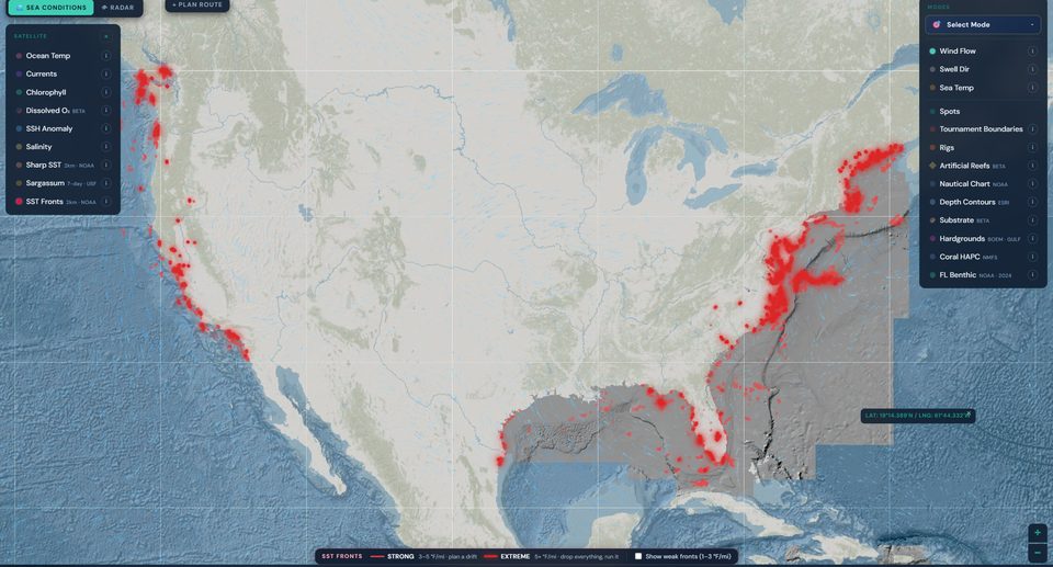
HELM Live Map showing SST Fronts overlay — red dots along US coastlines mark sharp sea surface temperature gradients
SST + SHARP FRONTS
Sea surface temperature with sharp gradient detection. Pelagics stack on the temperature break — HELM puts the line on it.
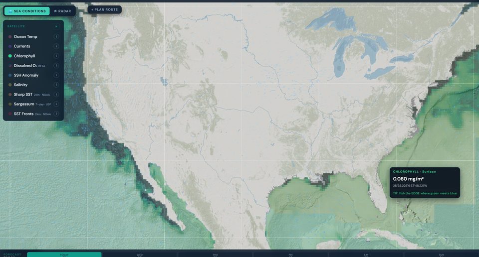
HELM Live Map showing chlorophyll concentration overlay — green-water-to-blue-water transitions where bait stacks
CHLOROPHYLL EDGE
Green-water-to-blue-water transition mapped from satellite. Find the edge, find the bait, find the fish stacking on it.
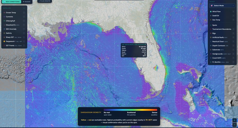
HELM Live Map showing sargassum density overlay — yellow and red areas mark workable weed mats
SARGASSUM & WEED LINES
Floating sargassum mats from USF satellite composites. Mahi, tripletail, and tuna run the weed lines — HELM shows you where they are.
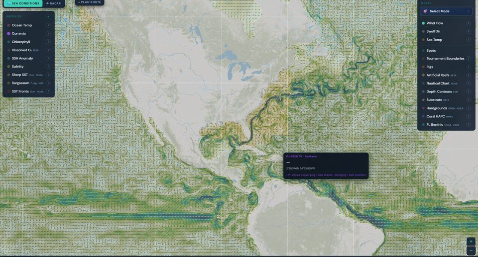
HELM Live Map showing surface currents overlay — directional arrows mapping the flow across the Atlantic and Gulf
CURRENTS & CURRENT EDGES
Live surface current direction and speed from Copernicus Marine. Pelagics follow the flow — converging arrows stack bait, diverging arrows scatter it.
Captain tier · 14 days free · No card required
UNLOCK CAPTAIN →
CROSS-VALIDATED AGAINST 8 INDEPENDENT MODELS
NOAA / NWSSTORMGLASSDWD / ICONNOAA GFS ECMWFAIFSOPEN-METEOWAVEWATCH III
SIMPLE PRICING
14 DAYS FREE. NO CARD REQUIRED.
Start with the free trial. When it ends, pick Lite, Pro, or Captain.
LITE
$50 / year
Conditions Only
  • Raw 7-day hourly forecast
  • Coast-to-coast — every US region
  • Wind, swell, tides, solunar
  • NOAA marine warnings
  • Spot picker + 5 custom spots
  • Cross-validated against NDBC buoys + NASA satellite data
  • No Go/No-Go verdicts
  • No Set Your Limits
  • No Live Map or Captain's Log
GET STARTED →
PRO
$19.99 / month
⭐ FOUNDING MEMBER: $143.93/yr — 40% OFF FOREVER
Forecast & Decision
  • 8-model Go/No-Go engine
  • Coast-to-coast — every US region
  • 7-day hourly + 14-day extended
  • Best Fishing Window AI
  • Tides, solunar, swell analysis
  • NOAA marine alerts
  • Cross-validated against NDBC buoys + NASA satellite data
  • Plain-English daily forecast cards
GET MY FORECAST →
CAPTAIN
$29.99 / month
⭐ FOUNDING MEMBER: $215.93/yr — 40% OFF FOREVER
Full Offshore Intelligence
  • Everything in Pro, plus:
  • Live Weather Map — every overlay
  • SST + sharp SST gradients + fronts
  • Chlorophyll, salinity, currents, sargassum
  • Bottom substrate (gravel, mud, hardbottom)
  • 29,000+ artificial reefs across 17 states
  • 1,000+ Gulf oil & gas rigs (BSEE)
  • Live NDBC buoys + NASA satellite — directly on map
  • Species intelligence (400+ species)
  • Custom spots + bulk CSV import
  • Captain's Log — GPS + catch log + heatmap
  • Reference Library — search rigs/reefs by region
  • Offshore route planning
  • Works offline — 50mi from shore
GET MY FORECAST →
EXPERT — AI on-demand analysis · coming soon